Saturday, June 22, 2013

Lesson 10 : Tape measurmenets 3

Equipments used with taping 1) Plumb bob  Used to ensure a horizontal reading is obtained . 2) Range poles  painted alternately red and white . Used as upright guides when chaining or marking turning points . Types of tapes : great variety exists : 1) According to the material :  steel and steel alloy  metallic or non-metallic  polymers  Invar         1) nickle...

Lesson 9 : Tape measurmenets 2

Units of length : 1) Metric system  Adopted as international system . The meter is the length of the path traveled by light in vacuum during a time interval of 1/299792458 of a second . 2) Imperial ( English ) system :  foot . the popular belief is that original standard was the length of a man's foot . the foot used today is the imperial foot , which is defined to be exactly 0.3048 meters . Units of Area : 1) Imperial ( English...

Lesson 8 : Tape measurmenets 1

Introduction 1) one of the fundamental operation in surveying is distance measurement  . 2) distance measurement can be done by : passing  wheels  taping  also the term chaining is used . the oldest instrument used is chain  later on tape  3) stadia method  the distance is computed from angle measurements and staff readings . 4) electronic distance measurement - the most modern technique . ...

Lesson 7 : Taping

Taping  Considered by many to be the most accurate of manual measurement .  A crew of two persons are referred to as a head chainman and a rear chainman   Accuracy of measuring with a tape come from knowing the equipment .  Source of errors when taping  Tape of incorrect length  Tape not horizontal  Incorrect alignment  Random errors   ...

Lesson 6 : Sources Of Errors

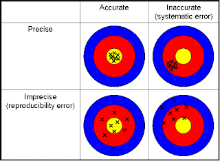
 Sources Of Errors  1) personal errors  no surveyor has perfect senses of sight and touch  2) Instrument errors  devices cannot be manufactured perfectly wear and tear and  compatibility with other components  . 3 ) Natural error  temperature , wind , moisture , magnetic variation , etc . 4) Systematic error  Known as cumulative errors . Correction can be made to eliminate...

Lesson 5 : Conversions of unit of measuring

Conversions of unit of measuring  As a student you must store these basic parameters in your mind to use it but in future you can used a lot of alternatives to convert between units  1 yard = 3 feet  1 meter = 39.37 inch = 3.2808 feet 1 degree = 1/ 360 of the angle around a point   1 degree = 60 minutes  1 radian = 57.3 degrees  1meter = 100 cm = 1000 mm = 1.0936 yd  1 kilometer = 1000 m = 0.6214 mile  1...

Lesson 4 : The methods and equipments used in measuring

 The methods and equipments used in measuring   a variety of methods and equipments can be used to measure each of these parameters . 1)Horizontal distances by : Taping . Optical method . Electronic methods  . 2)Vertical distances by :  Taping  Optical method  Electronic methods   3)Angles by : Magnetic compass . Sextant . Theodolite . ...

Lesson 3 : Land surveying

 Land surveying This area of surveying can be broken down into the following: Geodetic surveying . Topographical surveying  . Photogrammetry. Hydrographic surveying. Cadastral surveying . Engineering surveying . We are going to concentrate on this last aspect although the basic techniques can be employed to most of the others . Engineering surveying is used   at the concept and design stage for production of maps...

Lesson 2 : Types of surveying

Types of surveying  1) boundary and cadastral surveying  Related to separation and mapping of property boundaries . 2) plane surveying  concerns small area project and surveying work where earth curvature can be neglected . 3) Topographic surveying  The third dimension - heights - is included . 4 ) Geodetic surveying  concerns large area surveying works such as geodetic networks , etc .  earth curvature...

Friday, June 21, 2013

Lesson 1 : definition of surveying

 Definition The simplest definition of surveying is that :  The definition of surveying include these main points 1) earth measurement distances : horizontal ,slope and vertical angles :horizontal , vertical , zenith , azimuth      2) determination of relative position of points located on above or below the earth's surface 3) The final output is positional information as : maps : digital or paper&n...

preface

preface  Before I started , I want to tell the visitors of this blog why I want to write about this subject exactly ( surveying in civil engineering ) , the reason is that when I was student the surveying course was very complicated respect to me so now I will try to make this course easy for all Civil Engineering students in the world After I studied this course hard and got high mark in it I will write about it , surveying  in...